

|
|
| SDAG home | Meetings | Field Trips | OSW | Announcements | Sponsors | Jobs | Publications | Geologic Links |
SDAG One Stop Wonder - Encinitas Copper Mine |
OSW - Encinitas Copper Mine - Write Up by Jennifer MortonEncinitas Copper Mine (a.k.a. Danes Lea Mine) N33.081651 W117.208037Rancho Santa Fe Quadrangle Directions: Take I-5 to La Costa Avenue, head east. Turn left onto Rancho Santa Fe Road and right onto San Elijo Hills Road. Bear right at the roadway to a closed landfill and park on the side of the road. Head south on the easternmost dirt path, next to the landfill building. Arrive at the head of Copper Creek trail. Follow this trail until you reach the waterfall and remnants of the mine workings. 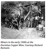 On September 1, 2018, SDAG visited the site of the Encinitas Copper Mine in the La Costa Preserve.
The old mine was situated along what is now known as Copper Creek.
According to County Report 3, Geology and Mineral Resources of San Diego County, California, published by the California Division of Mines and Geology in 1963, the mine was discovered in 1887 and was worked until 1917. On September 1, 2018, SDAG visited the site of the Encinitas Copper Mine in the La Costa Preserve.
The old mine was situated along what is now known as Copper Creek.
According to County Report 3, Geology and Mineral Resources of San Diego County, California, published by the California Division of Mines and Geology in 1963, the mine was discovered in 1887 and was worked until 1917.
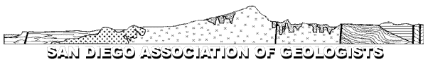
We were joined by Richard Bumann, local author/historian and a descendent of one of the founding families of Olivenhain. Mr. Bumann's uncle owned the copper mine from the 1920's through 1940's, and he shared some of the history of the mine and boyhood stories of exploring the mines and at one time lowering himself into one of the shafts! Mr. Bumann confirmed that the mine consisted of two shafts, one on either side of the canyon through which Copper Creek flows. The mine was worked sporadically until 1917, producing a low-grade extract than it would be worth! Piles of light-green rocks - the remaining mine tailings - give away the locations of each of the shafts, which have since been blasted shut for safety. The shaft on the east side of the canyon consisted of two horizontal tunnels terminating at a 140-foot deep vertical shaft, and the shaft on the west side was reported to be a vertical 400-foot shaft. The shafts tend to flood with groundwater, and Mr. Bumann's uncle spent many months pumping out water and restoring the shoring in 1925, but the mine was never again worked. 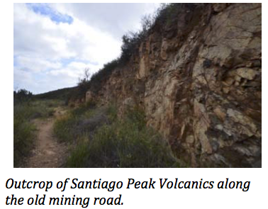 According to the 1963 County Report, the deposit is a northwest-trending zone copper-bearing mineralization, approximately one mile long and 10 to 50 feet wide.
The 1939 California Journal of Mines and Geology, Quarterly Chapter of State Mineralogist's Report XXXV describes the vein as a yellowish and black gouge between walls of dark-colored porphyry, and notes that the ore is chalcopyrite associated with pyrite.
According to the 1963 County Report, the deposit is a northwest-trending zone copper-bearing mineralization, approximately one mile long and 10 to 50 feet wide.
The 1939 California Journal of Mines and Geology, Quarterly Chapter of State Mineralogist's Report XXXV describes the vein as a yellowish and black gouge between walls of dark-colored porphyry, and notes that the ore is chalcopyrite associated with pyrite.
 Steven Jacobs provided a great overview of the formation of porphyry copper deposits. These types of deposits typically form as the result of hydrothermal activity.
In the case of the Encinitas Copper Mine, as the magma body of the Western Peninsular Ranges Batholith intruded the Santiago Peak volcanics hydrothermal fluids circulated through preexisting rocks, altering these rocks and depositing metals in the matrix or as a coating in fractures on the surface of surrounding rocks.
Steven Jacobs provided a great overview of the formation of porphyry copper deposits. These types of deposits typically form as the result of hydrothermal activity.
In the case of the Encinitas Copper Mine, as the magma body of the Western Peninsular Ranges Batholith intruded the Santiago Peak volcanics hydrothermal fluids circulated through preexisting rocks, altering these rocks and depositing metals in the matrix or as a coating in fractures on the surface of surrounding rocks.
Monte Marshall was on hand to discuss the formation of the Santiago Peak Volcanics. These are subduction-related volcanoes, similar to the Andes or the Cascades. He noted that a visible outcrop near the mine consisted of a volcaniclastic deposit - one of three types of structures typically seen associated with the Santiago Peak Volcanics. Others include flows and feeder dikes with vertical foliation. Thank you to everyone who made this a successful OSW! |