

|
|
| SDAG home | Meetings | Field Trips | Announcements | Sponsors | Jobs | Publications | Geologic Links |
Why Prepare for an Earthquake in San Diego? May 27, 1862 known as the "Day of Terror"Do we have earthquake amnesia? Did you know the San Diego area experienced its strongest shaking and documented damage from a local earthquake on May 27, 1862, known as the "Day of Terror." The exact location and magnitude of the epicenter from the 1862 earthquake is not known because there were no recording devices at that time. Legg and Agnew described the 1862 earthquake in their paper published in the 1979 San Diego Association of Geologists publication. The Los Angeles Star newspaper referred to this earthquake event as San Diego's "Day of Terror." Today the 1862 earthquake has been estimated as a magnitude of 6.0 to 6.2. Buildings were damaged in Old Town, the Point Loma Lighthouse was cracked and liquefaction type damage was documented. The approximate location of these earthquake effects are shown on a current map of San Diego as were reported by residents in 1862. The City of San Diego census lists 731 residents living in the Old Town area of San Diego in 1860. Today the City of San Diego is the 8th largest City in the United States with approximately 1.4 million residents. This is a reminder that the San Andreas isn't the only fault in California capable of producing damaging earthquakes in the San Diego area. A known earthquake hazard is easier to prepare for than an unknown.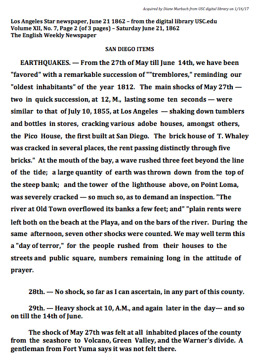

Please read and participate in the Great ShakeOut Earthquake drill on Thursday October 17, 2019 at 10:17am "Drop, Cover and Hold On."SD-TJ Fault Map with May 27 1862 Quake Reports 11X17 reduced (1MB) |
DRAFT Provisional Fault Map for San Diego/Tijuana Earthquake ScenarioNote: California Geological Survey (CGS) Fault data uses the scale 1:24,000 [v.3.0, 2016]. CGS suggests users defer to San Diego City fault data, where marked, for increased accuracy. SD City Faults: Location and activity of faults are based chiefly on interpretation of information contained in geologic reports by private consultants. The City of San Diego identifies active faults as Holocene (<= 11,000yr) and potentially active as Quaternary (up to 1.6my). Fault investigations are ongoing that may require future revision of this map. This map is not a substitute for a site specific fault investigation. Clicking on a line/feature will reveal metadata. Solid lines are well located at 1:24,000. Dashed lines are approximate at 1:24,000. Dotted lines are concealed faults. |